The Neighborhood of Tallahoma
The indigenous people here in the Piney Woods were the Choctaw Indians, as far as I know. Their people lived all through the red clay hills of this land. Some foresters can find their camp grounds by just recognizing the pattern of high land close to water. They date the camps near 10,000 years old by recognizing the stone flakes discarded from tool making. Usually these locations yield all sorts of Native American artifacts.
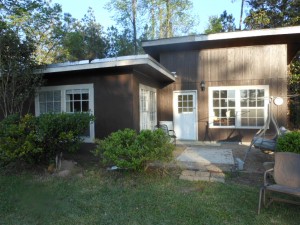
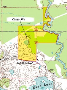
When I moved back to Laurel, I moved into the cabin pictured here.  It had been built by my father around 1960 on a parcel of land at the back of the place he called “The Farm”. An understanding of topographical maps reveals that this cabin site lies on a parcel of land made up of a peninsula jutting into the Tallahoma Creek bottom. Today the creek runs ¼ mile to the north, but once it ran along the edge of the drop off. The Choctaw people used this spot for their home, since it’s high, dry, yet close to water.
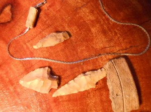
 Over the years I have found the remains of this camp. Points, a bead, pottery, and piles of stone flakes left from the making of their tools show up every time a bare patch of dirt gets scrubbed by a hard rain.
 One day, I shall name the land formally and will use the Choctaw names for my guide. My friend, Bonnie Carter, in Natchez spent a good deal of time in another life analyzing the Mississippi Choctaw language as part of her linguistic PHD program. Of the language she says that so much of her understanding came from various Choctaw informants with whom she worked. In her words, “Translating without an informant is difficult for several reasons, ..” As an aside, isn’t ‘informant’ a word so rich as to make one imagine whispers in the teepee.
 It had been built by my father around 1960 on a parcel of land at the back of the place he called “The Farm”. An understanding of topographical maps reveals that this cabin site lies on a parcel of land made up of a peninsula jutting into the Tallahoma Creek bottom. Today the creek runs ¼ mile to the north, but once it ran along the edge of the drop off. The Choctaw people used this spot for their home, since it’s high, dry, yet close to water.
 Over the years I have found the remains of this camp. Points, a bead, pottery, and piles of stone flakes left from the making of their tools show up every time a bare patch of dirt gets scrubbed by a hard rain.
 One day, I shall name the land formally and will use the Choctaw names for my guide. My friend, Bonnie Carter, in Natchez spent a good deal of time in another life analyzing the Mississippi Choctaw language as part of her linguistic PHD program. Of the language she says that so much of her understanding came from various Choctaw informants with whom she worked. In her words, “Translating without an informant is difficult for several reasons, ..” As an aside, isn’t ‘informant’ a word so rich as to make one imagine whispers in the teepee.
 It seems that the names for most places were first put in writing by the French or Spanish as they plundered through these big woods meeting a good people with a rich vocabulary. The British later Anglicized their words, and we locals Southernized them, without permission.
Any conversation with Bonnie, no matter what form, is wonderful fun, and even better, stimulating. When this one ended it was clear that “homa” means “red”, and “Talla” means “Stone”.
As far as I know, the only stones we have in the piney woods are red sandstones. They are often exposed as the red clay, mostly made up of sand and iron, gets eroded. They are not very hard and are usable only for brick-like construction. Laurel, Mississippi lies in the virtual confluence of the Tallahoma Creek on the West and Tallahala Creek on the East. Both originate in Jasper County where there are many more sand stone exposures than here in Jones County. When in the fall, the waters of all the creeks in this area run clear, they run a rusty red. Surely it’s part iron rust, just like water from any shallow water well at my grandmothers place. It was so rusty you could taste old nails. It was so strong that it stained porcelain bowls.
